GNSS signals come from space so a ‘line of sight’ to the sky is required
Physical obstructions to the sky can affect the number of satellites you track and your position accuracy
● Working under Tree canopy
● Close proximity to tall buildings
● Multipath (signals bounce of buildings)
This becomes more important when working offline as we use RTX over satellite to deliver your corrections
In difficult environments you may need to wait longer for the accuracy you need
Some environments are just too difficult for GNSS
If this is the case when taking points the operator can manually "move" the points taken which are not in the correct position due to low accuracy GPS location.
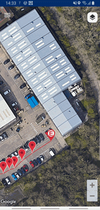
Move
The move function let's you change the position of the selected measurement pin on the map. This is useful if the pin position is not accurate.
To use this function:
- Select the Move icon
- Use the Google Maps pan, zoom and rotate functions to position the map in your preferred orientation and showing the desired level of details
- Move the Map with your finger for course positioning
- Use the arrows keys for fine adjustments
-
Press Confirm to move the marker
or
Press X to exit this function
Caution: Moving a marker cannot be reversed
Note: Any location coordinates obtained from an external GNSS device, the mobile device and locator are preserved in the survey measurements data.
|
|