GPS menu (MRX G Only)
The MRXG Marker locator can be paired to an external GPS device or use its internal GPS module when fitted to detect and store its latitude, longitude and accurate UTC time alongside its locating data or the automatic logging system (MRXG model only).
The presence of GNSS data allows for the data to be mapped easily and to export and save the information directly into GIS systems.
GPS menu
To enter the GPS menu:
- Press the
 key to enter the menu.
- Scroll to the GPS menu using the
 or
or  keys.
keys.
- Press the
 key to enter the GPS menu.
Use the or keys to scroll through the 5 options:
- RESET: Select YES to reset the internal GPS.
- OFF: Select this to switch off the internal GPS module and save battery.
- EXTM: Select this to use GPS from RD MAP+ (features need to be enabled in the app).
- INT: Select this to use the internal GPS if present.
- EXIT: Select this to exit the GPS menu
4. Press the  key to accept your changes and exit the GPS menu.
5. Press the key to exit the menu.
When SBAS is ON the GPS system may take longer to lock.
BT Reset impacts both SMLOG and iLOC.
Re-pair your MRXG Marker locator with your chosen mapping app after BT Reset and restart the app.
BT Reset only applies to BT classic, not BLE (used for iOS).
Internal GNSS ‘GPS’
The MRXG Marker locator has an internal GNSS module. When internal GPS is enabled, it will automatically try to “lock” onto a number of satellites as soon as the MRXG Marker unit is turned on.
The time required for the GNSS module to lock onto the GNSS system varies depending on the length of time that has passed since the last time the locator was used, and on the presence of obstacles (like high buildings, trees, etc.) that obstruct sight to the sky.
If the unit has not been used for several days the time to first fix may take up to several minutes.
The MRXG Marker locator display provides a number of icons indicating the presence of an internal and active GNSS and when this has locked to the GNSS system, the quality of the signal received or numbers of satellites received.
The accuracy of the GNSS module is affected by the number of satellites received and best accuracy is only reached when the signal quality is at its maximum.
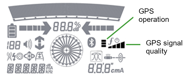
GPS Icons
The LCD GNSS operation icons provide visual information about the status of the internal GPS module:
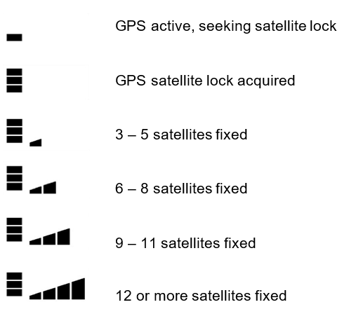
GPS status and satellites in view