So basic GPS as we have described relies on a complex waveform and works great to get accuracies to several feet/meters, but to get sub-meter accuracies things start to get even more complex and costly.
Assuming a clear view of sky, most GPS errors are caused by propagation delays as the signals pass through the Earth’s various atmospheric layers (there are clock and system errors also, but these are less significant).
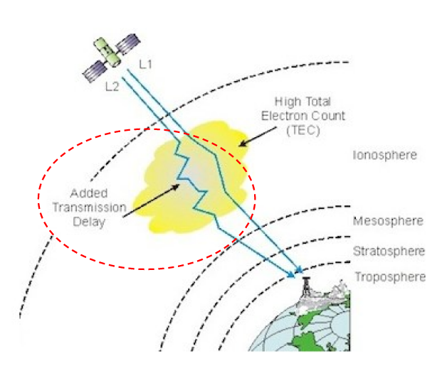 |
As we learnt in the article "How do we get a Long/Lat position?", the measurement of the transmission time of the GPS satellite signals are critical to the process of calculating Long/Lat. The Earth’s atmospheric layers are distributed across the planet and one satellite can be affected differently than another - so this unknown must be accounted for if we are to get below 1m accuracy. This is achieved by using more than one Satellite frequency and comparing the response of how each frequency travels through the atmosphere. These frequencies are known as L1 & L2 (and most recently a new L5 frequency). |
Here is your quick-and-easy summary explaining L1 & L2 signals and how they are used:
| L1 signal (1575.42 MHz) is decades old, is the cheapest GPS solution and is only accurate to 2 or 3 meters at best. |
| L2 frequency was implemented after the L1 and uses a lower 1227.60 MHz frequency that allows the signal to better travel through obstacles such as cloud cover, trees, and buildings. L2 is used together with L1 to correct for atmospheric effects and boost accuracy (at about twice the cost of L1 only and with higher battery consumption). |
UTTO - Copyright IPEG Corp 2023